Features
In the Field
Industry
Droning it Home
November 1, 2016 By Paul Dixon
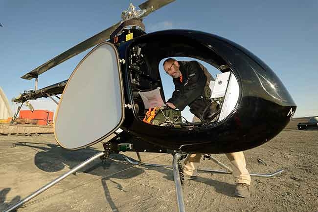 UAV team member Dale Anderson prepares the Aphid UAV for a demonstration at CFS Alert. The 2014 tests carried out at Canadian Forces Station Alert, Nunavut, explored the potential for future military concepts. Janis Lang (DRDC)
Call it the dawn of the rise of the machines. To their supporters, Unmanned Aerial Vehicles (UAVs) represent the next greatest thing since sliced bread, with the potential to shape our lives to the same extent as the personal computer and smartphone have to previous generations.
They exist by many names – drones, UAVs and Remote Piloted Aerial System (RPAS) to name just a few – and they’ve actually been around for quite a while, if more in concept than in application. In military circles, UAVs have been actively used for surveillance or “battlefield awareness” for close to 50 years. Operating largely in an “out of sight, out of mind” world, UAVs came into public prominence when weapons were fitted to them and they were turned from passive information gathering systems into offensive weapons.
On the civilian side, Jeff Bezos stunned the world when he revealed Amazon’s planned drone delivery system, Prime Air, on 60 Minutes in 2013. Others quickly jumped on the bandwagon, promising to deliver a wide range of consumer products by drone. Standing in the way were regulations in the U.S and many other countries that did not permit the commercial operation of UAVs, for any purpose. The Convention on International Civil Aviation introduced the first international agreement in 1944 by mandating that UAV flights would require authorization to fly. Few countries had specific legislation addressing UAV operations and have only begun to address the issue in recent years.
The Canadian Aviation Regulations (CARs) applicable to UAV flights were introduced in 1995, but is was several years before but it was well into the new millennium before Canadians started taking for the Special Flight Operation Certificate (SFOC) that would address the time, area and purpose for which the UAV would be approved to fly.
In 2007, there were 44 SFOCs issued in Canada. By 2012 that number had grown to 229, and under the current regulations, the number is projected to exceed 5,000 by the end of 2017. Transport Canada (TC), after extensive consultation with the UAV community, is expected to announce new regulations in the second quarter of 2017, in order “to both safely integrate UAVs into Canadian airspace and encourage innovation within this important new subsector of civil aviation.”
Preliminary indications are that there will no longer be a distinction between recreational and non-recreational users, different categories for small UAVs, knowledge requirements for operators commensurate to the category of their aircraft, making the age requirements the same as manned aviation licensing and requiring liability insurance for all categories of UAVs.
After much pressure from legislators in Washington, D.C. in recent years, America’s would-be UAV pilots gained their wings on August 29, when the Federal Aviation Administration (FAA) introduced new rules that more closely approximate the Canadian regulations. Previously, operators of UAVs were required to hold a private pilot’s license and attaining approval for flights, while not impossible, was described by many as “very difficult.”
Today, commercial drones can be operated by persons over the age of 16 who have passed an FAA aeronautical knowledge test at an approved facility and has passed a TSA background check. Rules are much the same as Canada – daylight only, line of sight, etc. Estimates vary widely as to how many commercial UAVs could be operational in the U.S by the end of 2017, but range as high as 60,000.
A Look at the Landscape
For would-be commercial operators of UAVs, there are two very large pieces to the puzzle – the UAV itself and secondly, what it is that you will be doing with the UAV, whether you are going to operate a UAV and offer its service to others, or incorporate one or more UAVs into your current business. UAV operators need to realize that these machines are aircraft and that’s how they should be operated.
Just as with a manned aircraft, the safety of everyone concerned, other aircraft and the public at large, is key. The rules and restrictions regarding UAV operations have one simple goal in mind – safety; and no one has a larger stake in safety than the insurance industry.
Jeff McCann is vice-president of digital strategy with Shaw Sabey, which offers insurance to the UAV community through DroneInsuranceDepot.com. His perspective on the UAV phenomenon is straightforward. “We’ve been in the drone business for some time now, but when TC first introduced the $100,000 minimum, that limit did not even exist, so we had to go back to Lloyds and have them create a $100,000 limit at a price point that we felt was sellable to our clients,” he said.
Richard Neal, account executive with Aon Risk Management’s Aviation group describes the current UAV environment as “fluid,” with the changing regulations in both the U.S. and Canada. “I’ve heard it said that it’s much like the development of motor vehicles over a hundred years ago,” he said. “It’s a new area where we don’t know what is happening or what is going to happen.”
Safe operation of UAVs, especially in urban areas is also a significant concern. This past June, TC launched its “No Drone Zone” campaign with Transport Minister Marc Garneau as the public face of the campaign. No Drone signs are going up across the country within many areas adjacent to airports and other no-fly zones.
Ron Campbell is the RPAS (Remote Pilot Aviation Systems) advisor for Calgary-based SGS Hart. Campbell stresses that UAVs are an aviation activity and suggests “there’s 110 years of experience in learning how to do aviation activities safely, so why can’t we take what we’ve learned from the manned world and move it to the unmanned world? We’ve followed ICAO standards and recommended practices, which have been coming out for the unmanned world. It’s essentially a robust standard that addresses operational and airworthiness issues.”
The future, as Campbell sees it, is still just over the horizon in terms of UAV development and the next generation of regulations. “You’ll never make a living with an electric UAV that flies 20 minutes at a time. There will be a few who get some work and good for them.”
The future is bigger UAVs that can stay aloft for much longer, even for days at a time, as the key to making them economically viable. As the technology improves, regulations will have to change as far as altitude restrictions as well. With 400 feet currently the maximum altitude, that may not be the optimal altitude for the job.
“For pipeline patrol, you’re going to need to pop up to 1,000 or even 2,000 feet to cover any meaningful territory,” Campbell said. “And yet another consideration as distances grow is communications. Radio is line of sight, so how are you going to communicate with it as well? Are you going to get a satellite subscription to be able to communicate and pass data back and forth?”
The Innovation Buzz
In February 2016, the British Columbia Institute of Technology (BCIT) hosted “Drone Fair” at its main campus in Burnaby. The first of a several held across the country, Drone Fair was touted as “celebrating the positive uses of drone technology” with the aim of educating people already using UAVs or learning more about UAVs about best practices and safety measures.
BCIT’s Chris Cambon said that organizers were pleasantly surprised when the event drew almost 1,000 people, twice what was anticipated and with minimal advertising. A self-described technology geek, Cambon is BCIT’s video and digital media producer and production coordinator. He added UAVs to his department two years ago to capture dynamic shots and carry payloads for specific tasks. Interest in the potential for uses of UAVs has spread across the BCIT campus, while Chris and pilot Tim Horsfall, have worked on creating a UAV certification program, working with the BCIT Aerospace Program, TC and private industry. It’s just one of several educational institutions popping up nationwide offering UAV training and education.
Drone Fair offered a smorgasbord of UAV exposure to those who attended – from a series of presentations dealing with the legal issues around UAVs, regulations and privacy issues, displays by local and national UAV vendors and even the opportunity to test fly a small UAV inside a racquetball court.
So, What Value Does a UAV Bring?
For many businesses, the case for using UAVs appears straightforward. UAVs are far less expensive to operate than helicopters or fixed-wing aircraft and much quicker than humans on foot. For the cost of hiring a helicopter or fixed-wing aircraft for aerial survey work for a day, for example, a UAV can be used for ongoing missions over weeks or months, collecting data far more frequently and providing end users with accurate information on a timely basis. Popular applications include aerial firefighting, construction, pipeline inspection, search and rescue (SAR), security management, accident reconstruction, real estate and more.
A key consideration for most end users is using the most effective or appropriate sensors (tools) for the job at hand to get the best quality information which will then allow the most efficient allocation of resources on a site, while minimizing potential issues and speeding up work processes which all translates to the bottom line.
David Carlos is one such business owner. He started a small company, Victoria Aerial Photos and Survey, in 2012 to take advantage of the unique views he could offer with his UAVs. It took time for the idea to gain traction with potential clients, but one client led to another, and now it is a full-time business.
Aerial photography was his foot in the door, but a job for the provincial government opened other doors. The copper dome of the BC Legislature needed to be inspected, but due the age of the copper roof and its fragile state, putting workmen out on the roof was both dangerous for the workers and risked doing even more damage to the roof. An up-close inspection with the HD camera on his Carlos’ UAV produced the information required, posed no risk to the roof or staff and was completed in a matter of minutes instead of the hours it would have taken simply to rig safety lines for a physical inspection.
Carlos is a licensed private pilot and is a strong advocate that the key to success for potential UAV operators is understanding the regulations and getting it right from the beginning. In early 2014, it occurred to him there might be people out there interested in learning to learn how to operate a UAV properly, so he put together a course and got a pleasant surprise when six people registered. Two days of classroom instruction followed by a day of actually flying. Now, he offers one course every month and has provided in-house training to large companies looking to train a group of employees. “The most important thing for students to understand is that they are operating a real aircraft in real airspace,” he said.
Erik Bayfield is another operator who has hung out his shingle as Above View Aerials. With a background as a civil engineer, Bayfield has been using his DJI Phantom to provide near-ground, high definition photography to construction, engineering and government for the past year. In November 2015, he participated in Operation Windshield, a post-disaster exercise conducted by North Shore Emergency Management that simulated response to the aftermath of a 7.3 magnitude earthquake that has hit the Metro Vancouver region.
Bayfield provided inspection flights on three pieces of critical infrastructure, including a demonstration at the Mosquito Creek Bridge on Highway 1 for a large crowd of emergency managers from around the province. For Bayfield, “UAVs provide a quick and affordable way to get a bird’s eye view of a situation, assessing a scene and tracking changes over time.” In the wake of a major disaster, tracking changes over time could mean assessing critical infrastructure.
While the 7.3 magnitude earthquake wasn’t real, it was made as realistic as possible to better help municipal, regional and provincial emergency planners what they would be dealing with when the “big one” does occur. Mike Andrews, the emergency planning officer for North Shore Emergency Management, designed the exercise based on real information about soil densities, building types and demographics collected from the three North Shore municipalities. That information is then run through a special software package that models of the likely results of a particular earthquake. Having seen the utility of the UAV as a response tool, Andrews is now evaluating the UAV as a planning tool.
In Case of an Emergency
At BCIT, Cambon and Horsfall, along with their UAV, are now an official part of the school’s emergency response team. “We had a disaster day exercise here with RCMP, fire department and everybody,” Cambon said. “We got the UAV up in the air to fly over a simulated boiler explosion and we were able to get the fire chief to direct us to what he wanted to look at. It was a full scale exercise with the UAV involved and video streamed live to the main headquarters so the emergency operations centre see it. As far as I know, we are one of the first schools to implement a UAV team in their emergency response plan.”
Growing out of the emergency exercise experience, Cambon has had discussions with the RCMP and several local SAR teams. The potential for UAVs in this platform, in his opinion is endless – on a small or larger scale. “What we are designing right now is a very heavy-lift UAV, based on a Gryphon Dynamics X8 frame with eight 27.5-inch carbon fiber props and KDE heavy lift motors. It has swappable payloads for applications that could range from aerial cinematography, LIDAR, SAR tasks or even as a platform for a powerful LED area lighting system.”
Emergency Management BC is going full force in its UAV involvement. The organization is funding a one-year pilot program to investigate the use of contractors in providing UAV services to ground SAR teams. Led by Michael Coyle of Coquitlam SAR working with Kaizen Kinetics, the program will seek to determine what UAVs can do to support SAR and more importantly, what they can’t do.
Requesting the use of a UAV on a SAR mission would follow the same process as a helicopter is requested presently. As with helicopters, the UAV pilot would be in command and make any decisions regarding fly or no-fly. The realization is that a UAV will never replace a helicopter in SAR, but the challenge is to determine what missions a UAV could perform that a helicopter cannot. There is also the requirement to develop a SAR-specific SFOC and working with NAV CANADA and TC.
UAV team member Dale Anderson prepares the Aphid UAV for a demonstration at CFS Alert. The 2014 tests carried out at Canadian Forces Station Alert, Nunavut, explored the potential for future military concepts.
Into the Fire
In recent years, there have been many reports of unauthorized UAVs shutting down aerial firefighting efforts when they were spotted inside closed air space. But now, fire organizations such as the BC Wildfire Service have officially added UAVs to its firefighting fleet after evaluating for the previous two years for mapping and scanning of fires. The UAVs have been used for thermal imaging, hot-spot detection and fire perimeter mapping, work that was largely done by helicopters before.
UAVs don’t require on-board personnel and can be used at night and in more dangerous situations. Fire information officer Erin Catherall stated that “based on the feedback we’ve received from crews and our fire line operations staff, is has been of great benefit for our fire line operations.” It was also mentioned that UAV operations cost far less than helicopters. BCWS hired two UAV contractors for the 2016 fire season.
UAVs have also allowed biologists to monitor whales off the Pacific Coast of Washington and British Columbia in ways never imagined before. The Vancouver Aquarium has partnered with the U.S. National Oceanic and Atmospheric Administration (NOAA) to study killer whales from 100 feet directly overhead and observe behaviour in ways never possible before.
And there are other environmental uses. UAVs are rapidly being embraced by the agricutural community in a variety of capacities such as crop management and more, while The National Research Council of Canada (NRC) has partnered with TC, the Canadian Coast Guard and the Royal Canadian Navy to explore, demonstrate, and evaluate the potential of unmanned aerial vehicles in coast guard icebreaking and maritime ice-monitoring operations.
Trials using a Schiebel Accepter S-100 platform, were conducted in March near Fogo Island off the northeast coast of Newfoundland, aboard the Canadian Coast Guard ship George R. Pearkes. “Our collaboration with federal agencies such as the Canadian Coast Guard is one of the ways NRC is helping advance unmanned aerial vehicle technology into new areas,” said Ian Potter, vice-president of Engineering at NRC. “Our knowledge and data analysis capabilities will help to inform future operational and funding decisions within the Government of Canada.”
Defence Research and Development Canada (DRDC) and the NRC have also developed a computer model that allowed a UAV to control itself in virtual simulation. Meggitt Training Systems performed the test flights and developed a methodology to switch between autopilot and remote modes. An ultralight helicopter was converted into a UAV named APHID to fly over Arctic terrain. Outfitted with GPS, cameras and a cargo mechanism, APHID was designed for light cargo delivery. Operating from CFS Alert in August 2014, APHID was involved in an exercise designed around a downed satellite. The UAV demonstrated low-altitude high-resolution photography and radiation survey capability over land, sea and ice.
The Sky Really is the Limit
The above examples are just a very small sampling to illustrate how UAVs are being utilized by businesses and organizations across Canada to innovate, cut costs and essentially drive innovation and opportunity. As the regulatory environment in Canada matures and technology improves, UAVs will continue to be introduced into the civilian operating environment, creating opportunity but challenging traditional safety paradigms. Adaptation and flexibility in this brave new world – the rise of the machines – will be paramount. But the sky is truly the limit.
Print this page